

Safe and uninterrupted road travel is crucial in the aftermath of storms so that people can access medical treatment, downed power lines can be removed and communities can begin a return to normalcy.
Researchers with the FAMU-FSU College of Engineering’s Resilient Infrastructure and Disaster Response (RIDER) Center are investigating better ways to predict where road-clogging debris will be most severe after tropical cyclones. Their latest paper was published in the International Journal of Disaster Risk Reduction.
“This research is especially relevant as hurricane season approaches because it reminds us that we need a variety of tools to properly respond to these storms,” said Eren Ozguven, RIDER Center director and the paper’s senior author. “This paper describes an important tool and applies it to disasters in the Florida Panhandle.”
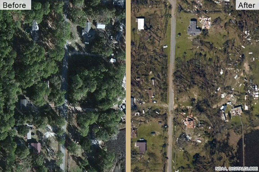
Researchers used satellite images to measure the amount of vegetation in Bay County, Florida, before and after two tropical storms and three hurricanes, including Hurricane Michael, a Category 5 storm that devastated the county in 2018. That gave them an estimate of how much vegetative debris those storms caused and where debris was heaviest. They were able to correlate debris measurements with factors such as wind speed, initial amount of vegetation and roadway density.
The researchers found debris was heavier in suburban and urban areas, which have a high density of people and roads, compared with rural areas. Although vegetation is not the only type of debris caused by a hurricane, it is an important predictor of where roads will be blocked.
Researchers aim to develop a tool that gives emergency management planners an estimate of the debris storms are likely to generate – allowing officials to plan, for example, where to position trucks and collection zones ahead of storms.

“The faster you can get debris off the roadway, the better you will be in terms of getting back to normal after a hurricane hits,” said paper co-author Tarek Abichou, a professor of civil and environmental engineering at the FAMU-FSU College of Engineering.
Along with understanding where to position resources before a storm, officials can use satellite imagery after a hurricane to quickly and inexpensively get an idea of post-storm damage before deploying first responders.
The work is part of RIDER’s efforts to use remote-sensing technology to solve civil engineering problems.
“Engineering is all about finding solutions despite obstacles, and hurricanes throw up all sorts of obstacles,” Abichou said. “Improving our ability to use remote sensing to prepare for and recover from storms will help us overcome those challenges.”
Former FAMU-FSU College of Engineering doctoral student Alican Karaer served as the paper’s lead author. Co-authors were Mingyang Chen of Harbin Institute of Technology; former FAMU-FSU College of Engineering doctoral student Mahyar Ghorbanzadeh; and Michele Gazzea and Reza Arghandeh of the Western Norway University of Applied Sciences.
This paper was supported by the National Science Foundation Coastlines and People (CoPe) Award 1940319.