By Olivia Sanchez
With the Atlantic hurricane season underway, Florida State University has several experts who specialize in industry-leading research related to these natural disasters.
Mark Bourassa is a professor of Meteorology in the Department of Earth, Ocean and Atmospheric Science, the associate director of the Center for Ocean-Atmospheric Prediction Studies (COAPS) and a member of the Geophysical Fluid Dynamics Institute. These groups aim to enhance our understanding of air and sea interaction and their consequences on the Earth, atmosphere, cryosphere and ocean systems.
Bourassa’s research interests include air/sea interaction, remote sensing related to air and sea interaction and precipitation and data fusion. His expertise is the transfer of energy and momentum between the ocean and the atmosphere and remote sensing, particularly of surface winds.
1. What impressions do you have of the NOAA’s hurricane guidance for 2025?
The NOAA’s forecast (60% chance of above normal activity; 30% chance of normal; 10% chance of below normal) seems reasonable. This can be interpreted as expecting a season that will be a little more active than usual. There is a wide range of activity in ‘normal’ and above ‘average.’ The number of storms is probably not the statistic that impacts people. What matters is where storms go and how strong they are at the time they hit. There are also more distant impacts associated with rain, flooding, waves and tornadoes. These details are beyond our ability to forecast, which is why the number of storms is discussed.
2. What are the biggest challenges in forecasting rapid intensification and why is it still so difficult to predict?
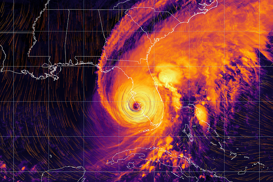
These questions are difficult to answer because the biggest problem is often that experts haven’t been able to identify what is causing the problem. That was true for rapid intensification until recently. In this case, our recent collaborative research (Yang et al, 2024, 2025) indicates that one of the big problems is modeling how sea spray modifies the transfer of energy from the ocean to the atmosphere. Hurricane winds rip many tiny droplets of sea water off the waves. Evaporation of these drops changes the amount of energy that is transferred from the ocean to the atmosphere. The energy to power a tropical cyclone is largely provided by condensing water vapor when rising air cools. The rate of this release of energy depends on how fast the air rises and how high it is, which depends on how much the ocean warms the air.
Warmer air is lighter than the surrounding air. This situation makes it more buoyant and causes it to rise. Our work indicates that sea spray increases this rate of heating. It is like making the tropical cyclone’s engine run faster, releasing more energy from water vapor. The rising air must be replaced by air flowing into the storm near the surface, which increases the rate warm moist air moves into the eyewall, which also increases the supply of energy to the storm.
Our work makes big improvements in our model’s ability to capture rapid changes in hurricane intensity. We’ve shown that one of the key missing details is how sea spray causes increased vertical motion and inflow of surface winds.
Other factors must also be important and remain to be identified. For about 25% of rapid intensification cases, adding sea spray to the model physics is only a minor improvement and errors in intensity remain large. There must be additional physical considerations we are still missing.
3. Can you explain the limitations of satellite sensors in capturing near-surface wind variability during severe storms and what advancements are on the horizon?
The issues differ depending on the technology used to observe surface winds. Some explanations include:
-
- We either can or can’t see through rain.
- If we can see through rain, we need longer radar wavelengths and are usually limited in resolution unless the satellite has a bigger and more expensive antenna.
- There are techniques that provide high resolution winds and can see through rain, with the caveat that directions are less accurate. The other problem with this technology is that it doesn’t cover much of the ocean surface.
In summary, we’d like to see through rain, have high resolution and have frequent coverage of the storms. Different approaches can give us two of these three goals, but at this time we can’t get all three.
4. What role does the global oceanographic and meteorological observation network play in improving short- and long-term hurricane forecasts?
The forecasts for seasons are highly dependent on the water temperature and global wind patterns. The global observing system is great for identifying large spatial scale variations, which are linked to patterns of surface temperature, wind, moisture, clouds and precipitation – all of which can be observed. These observations can be combined to get a good estimate of the large-scale wind patterns, which tend to persist for weeks to months.
Forecasts for individual storm tracks are highly dependent on the larger scale wind pattern through which tropical cyclones move and the position of fronts and high pressure systems. Weather satellites are great at providing this data. Intensity is influenced by how slow or fast the storm moves over warm water, the depth and temperature of warm water, interaction with land and other weather systems (e.g., fronts), and the amount of moisture at mid-levels. The combination of the oceanographic observing system and the meteorological observing system is helpful for measuring these characteristics along the storm’s projected path.
5. In your experience training meteorologists or emergency personnel, what are the most common misconceptions or knowledge gaps about hurricanes?
One of the most common misconceptions is the size of a hurricane. A lot of people think of the eye of a hurricane when thinking about scale. People realize that these are big systems, but they don’t appreciate how big. There is a tendency to underestimate the size by about a factor of 10. Most people understand that track forecasts have become awesome, but they don’t appreciate that a small change in track has huge consequences for people with property.
A lot of people don’t appreciate how fast a hurricane can change intensity in a way that is not in the forecast. These rapid changes are much harder to model than the better forecast slower changes. Our modeling improvements are not yet operational. Most people don’t appreciate how much productivity is lost preparing for storms well before they make landfall. Poorer forecasts would cause much greater loss in productivity and a greater loss of life.
People tend to think of eyewalls as cylinders (straight up and down), but they are tilted. It is easy to look at radar images of the eyewall well above the ground and be mistaken about the location of the eyewall’s surface winds.